News
ISPRS Geospatial Week 2025
16-04-2025
 The ISPRS Geospatial Week 2025 was held in Dubai from 6 to 11 April, organized by the International Society for Photogrammetry and Remote Sensing (ISPRS) in cooperation with the Mohammed Bin Rashid Space Centre. ISPRS Geospatial Week is a major international scientific event that brings together experts in photogrammetry, remote sensing, and spatial information sciences, providing a platform for sharing the latest research, technologies, and applications.
 more...
Demonstration Product - Ground Displacement Map for the Upper Silesian Coal Basin Area Now Available on NSIS!
11-04-2025
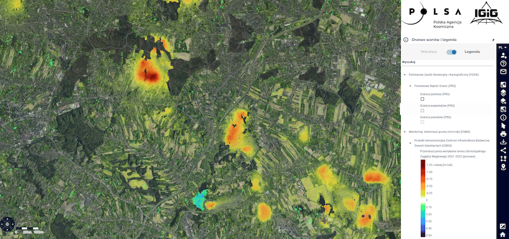 The integrated product developed within the Satellite Data Research Infrastructure Center (CIBDS) based on radar data, presenting ground displacement maps, is now available on the National Satellite Information System (NSIS) portal (https://nsisplatforma.polsa.gov.pl/aktualnosci/cibds_gzw). Previously available in the UPWr Knowledge Base, this product integrates data from the European Ground Motion Service (EGMS) with CIBDS’s DInSAR processing results for the Upper Silesian Coal Basin area, offering detailed ground displacement maps with higher resolution than the products previously available on NSIS. more...
COSPAR - Outstanding Paper Award for Young Scientist for Adam Cegła
11-04-2025

We are delighted to announce that Mr. Adam Cegła, has received an award from the Committee on Space Research for his work on integrated GNSS tomography. His article, "Application of integrated GNSS tomography in observation study over the area of southern Poland," has been recognized as one of the nine best publications in Earth Sciences in 2024, featured in Advances in Space Research. The article concerns groundbreaking research on integrating observations from both ground and satellite GNSS receivers to study troposphere dynamics. Congratulations!
more...IGiG Summer Internships 2025
26-03-2025
 The Institute of Geodesy and Geoinformatics presents a proposal of paid summer internships for students for 2024. The internships duration is up to three months. The titles and topics of the internships are in the appendix. The deadline for submitting applications is May 16, 2025. Please contact the tutors of individual internships directly (e-mail). more...
IGiG scientific seminar - Prof. Christian Heipke
06-03-2025
 IGiG is pleased to invite to a scientific seminar, which will take place on March 13, 2024 (Thursday) at 9:00 AM in the Room 100G (institute library), Grunwaldzka Street 53, Wrocław (Building C1). Prof. Christian Heipke from Leibniz University Hannover will give a lecture: "AI in photogrammetry and remote sensing".
Abstract: Photogrammetry is a technique for image capture and analysis, as well as 3D reconstruction from images, which has its roots in the 19th century. When space images became available, remote sensing was added to the name of the discipline. Recently, also the term computer vision has been extensively used to describe essentially the same methods, techniques and algorithms.
more...Archive: | 1 | 2 | 3 | 4 | 5 | 6 | 7 | 8 | 9 | 10 | 11 | 12 | 13 | 14 | 15 | 16 | 17 | 18 | 19 | 20 | 21 | 22 | 23 | 24 | 25 | 26 | 27 | 28 | NEXT PAGE »
 |
 |
 |
 |
Contact
|
INSTITUTE OF GEODESY AND GEOINFORMATICS
Wroclaw University of Environmental and Life Sciences Grunwaldzka 53 50-357 Wroclaw NIP: 896-000-53-54, REGON: 00000 18 67 Phone +48 71 3205617 Fax +48 71 3205617 e-mail: [email protected] |